

|
|
|
 |

The Old Home Place In Postcards
|
Now I'm going to write captions for these old postcards I've found. Since I don't know anything much about the subject, this is mainly just my way of getting a number of e-mails saying "What are you talking about, there!? Didn't you know that...?" Well, no I didn't. But I'll bet this is one Sure-Fire way to get information sent to this website☺So send your corrections, complaints, and any and all more Elkins pix and postcards to: |
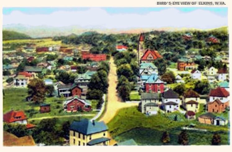
| OK, above is what remains the main drag in Elkins, "Randolph
Avenue" (US 33/250/219). You are looking from a hill to the
east of town (Elkins is
surrounded by 'em) toward more or less northwest, in the general
direction of the gap (off in the cloudy distance)
that Leading Creek cuts through the west wall of the Tygart River
Valley.
There's the big Randolph County courthouse (the orange-roofed tower) on the right. That was built around 1905 or so, after Elkins took county seat status away from the much older town of Beverly, and this courthouse still exists to this day. In fact, they've just restored a courtroom inside to original specs, and the building has lots of gorgeous stained glass, marble facings, and other Victorian touches. I think the roads visible here must be either gravel or not paved at all (see below for an update) - and there are no cars visible. So I'll bet we're talking World War I or so. As mentioned, the difference between these quiet lanes of the 19th Century and the car-choked streets of the 21st Century is pretty much just a layer of asphalt. Just beyond where that first right turns -- right where the tall red-brick house with the light blue roof is -- is now our local "Hardee's" and its great big parking lot. Traffic is often bumper to bumper in all directions on Randolph Avenue these days, so whenever anybody wants to turn left for a burger, it backs up cars all the way through town. |
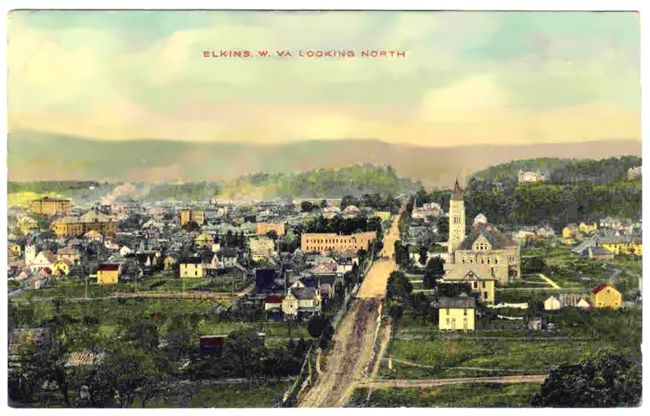
| Here is another, very similar view. It comes marked as "1915," and I think must be earlier than the first one. Notice how many fewer buildings are here! And the road has some kind of paving on it that STOPS just this side of the courthouse - if that's not mud in the foreground, I'll eat my hat. The Tygart Valley river is off somewhere generally to the left of this POV, by the way. |
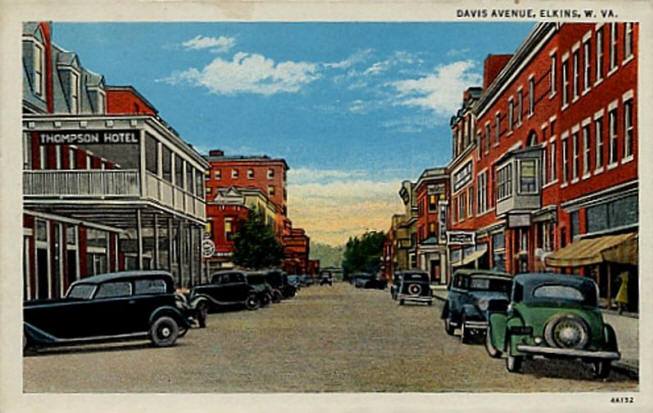
| This is downtown Elkins, looking basically south (I think), because that red-brick 'skyscraper' visible on the left is still there. Now known as the "Tygart Hotel," it goes up for sale periodically. Not much else here is very directly recognizable anymore, although I suspect there are a number of buildings shown here that have been hidden away in various remuddlings. The "Thompson Hotel" is certainly vanished. The building at right just beyond the intersection (after the fourth car on the right) is also gone, replaced by my bank. Directly across that same corner on the left, the mellow old red brick two-story with the tree in front of it is now disguised under a Jet Age expanded-aluminum-mesh facade. Little trees have recently been planted downtown - those shown here no doubt got the axe long ago. All of the big overhanging porches and balconies are also gone - they must have changed building codes at some point. Cars here say about 1930's, I think. And we've lost the diagonal parking, since then... |
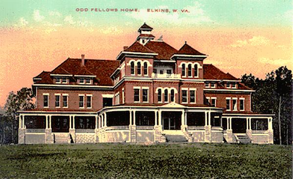
| The Odd Fellows Home sits up on a hill just south of town (I told you we were surrounded by 'em). I don't get up there often, but last time I drove by, the building looked a whole lot like this. Well, there were a lot more trees all around and they have certainly gotten very large since this postcard was made - Don Rice writes that the Home was built around 1909-1910. I have no idea what they are doing with the building these days - can there be that many Odd Fellows left? |
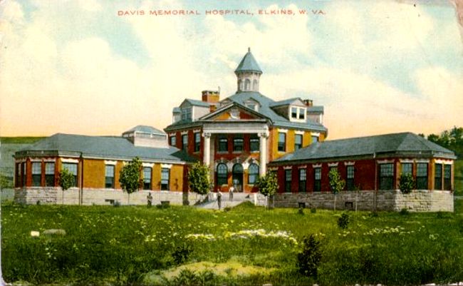
| Although Davis Memorial Hospital THE INSTITUTION still exists -- the only hospital for miles around -- Davis Memorial Hospital THE BUILDING (as in the one shown here) does not. According to Robert Whetsell's invaluable "Elkins, West Virginia: The Metropolis Revisited" this building was completed in 1903 and stood until 1979. As best I can figure, it stood about where the present DMH complex is now. |
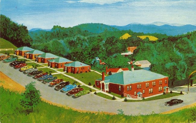
Speaking of institutions, here's a rather odd postcard view of the Elkins Motor Lodge (featuring the 1863 Tavern. ) If you ever drive by here today, you'll observe that the trees have grown up quite a bit since this painter (?) visited. You'll also be looking UPHILL at the other side of this place, because the main highway runs down in front, at the foot of this slope. (UPDATE 2014: A new owner has purchased the former Motor Lodge, torn down all of the quaint old tourist cabins pictured above, and is building the very model of a modern middling motor motel in their place. Progress.)
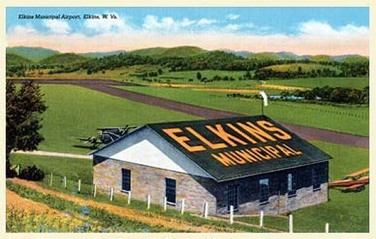
You know, I'm not certain if this is the same place as the current airport -- but it's a very similar setting, if not. Let's face it: enough flat land to make a runway is not exactly a dime a dozen, around here. Today's airport is a little bit fancier than this, but so far, nobody has been able to make a regular air passenger service pay enough to earn its keep here.